Methodology
We use the following effective geophysical methods:
- shallow refraction seismics enables to derive mechanical attributes of rocks (workability, rate of weathering) to the depth of approximately 20 m (according to distribution of velocity of propagation of seismic waves in the rock medium), or enables to determine the depth of the rock subbase surface


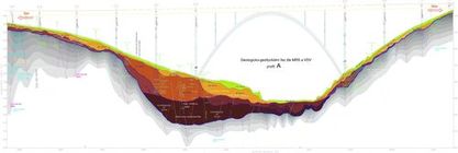
- shallow reflection seismics enables to study the deeper parts of the rock medium by studying of the structure of seismic reflections
- vertical electrical sounding (VES) enables to determine a rough lithology (average soil texture) and permeability of soils or rate of rock weathering


- resistivity profiling (RP) (usually by use of multicable) enables localisation of resistivity anomalies (like tectonic zones even with their rough slope)and tomography (ERT)
- multi-wire (multi- strand) cable enables to make a detailed spatial differentiation of rocks by their resistivity (which is reciprocal to the parameters of soil permeability and intensity of rock weathering or splitting)
- ground penetrating (probing) radar (GPR) with antennas frequency range from 50 to 900 MHz. Reflexes of electromagnetic waves from permittivity and resistivity anomalies bring the information about the structure of rocks to the depth of approximately 5 to 20 m
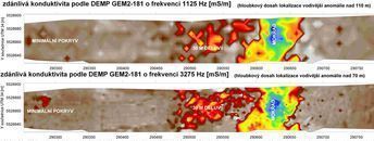
- dipole electromagnetic profiling (DEMP) enables to make maps of resistivity (or conductivity) and of magnetic susceptibility of the whole locality surface very effectively with up to 5 frequencies and working depth reachs (from 1 to X0 m according to resistivities)by instrument Geophex, GEM 2-181


- magnetometry (MM) (proton magnetometer PMG1V2.0 in abs. and grad. variant) enables to map magnetic anomalies (like anthropogeneous deposits, areas with increased content of metal ..)
- geotechnical attributes of quasihomogenous blocks (blocks specified by geophysical methods) can be obtained by using of lab tests on samples acquired from drill-hole or:
- static or dynamic penetration tests (SPT or DPT) can derive (in-situ) rock geotechnical parameters (like Ic,Id,f , c,Edef,Rdt)


